 9th December 2003, 01:22 PM
|
#1 |
|
Junior Member
Junior member
Join Date: Dec 2003
Posts: 2
|
Hi ^_^
I've just started using AC3D, and I've already made some little things to get me used to it. But now I need to design a (big) landscape. Does anybody know of some resources/tutorials/tips/whatever about modelling landscapes? Cheers, Jose |

|

|
|
9th December 2003, 06:13 PM
|
#2 |
|
Junior Member
Junior member
Join Date: Jun 2003
Posts: 7
|
I have tried various ways to use relief data from:
http://apex.ngdc.noaa.gov/seg/topo/globeget.shtml I imported the data in 3Dem and tried to get it to export it to a 3D-fotmat. Did not work for me. Though I got some 3D pictures and flyby's. http://www.visualizationsoftware.com/3dem.html Then I tried to export to Terragen from 3Dem. But no usable exports from Terragen either. http://www.planetside.co.uk/terragen/images.shtml Plugins for Terragen: http://www.terralab.net/tgpmanual/e_content.html I guess we need a import plugin for some kinds of DEM. GLOBE would be nice, though it is not that detailed. Anybody with tips? |
|
|
|
|
9th December 2003, 06:34 PM
|
#3 |
|
Administrator
Professional user

Join Date: Jun 2003
Posts: 4,565
|
I think others have used the AC3D point field format (.pf files) for this sort of thing - it's similar to a few of the ascii dem formats. From the plugin-about:
Code:
Field Import Plugin - Version 1.1 - by Inivis Loads a grid of points. The first two numbers in the file are the x, y size of the grid. this is followed by (x*y) heights in row order. This plugin then assembles a 3d mesh from these points. |
|
|
|
|
9th December 2003, 06:53 PM
|
#4 |
|
Junior Member
Junior member
Join Date: Jun 2003
Posts: 7
|
Here is a description of the file Format. http://www.ngdc.noaa.gov/seg/freeform/ffnd.html
Getting custom data, in my case The Netherlands: http://apex.ngdc.noaa.gov/cgi-bin/se...o/customdatacd I tried an ASCII file to look at the data. You can see it for yourself in one file by choosing the Transfer Option: Screen. When you choose the transfer by FTP you get 3 files. In the data file there are rows and colums of data. In the header files there are descriptions of the number of rows and colums and the offset point. Where do I get the pf-files? Can I change the Globe ASCII-files to pf-files by hand |
|
|
|
|
9th December 2003, 11:21 PM
|
#5 |
|
Junior Member
Member
Join Date: Oct 2003
Posts: 23
|
this almost seems too easy, but it works very nicely. with very little practice or effort, you can make some very nice terrains, very large, and easy to import into AC3D. here is the linkhttp://www.irony.com/igmmte and here is what is produced.
 this is all web based. it creates a vrml file that you can save to your harddrive and import directly into AC3D. enjoy, db this is all web based. it creates a vrml file that you can save to your harddrive and import directly into AC3D. enjoy, db
__________________
It\'s almost impossible to overestimate the unimportance of most things. |
|
|
|
|
10th December 2003, 03:56 AM
|
#6 |
|
Administrator
Professional user
Join Date: Jun 2003
Posts: 4,565
|
That's a great picture.
Bob, I just tried that web site and if you take the ascii data and add the the rows and columns numbers to the top of a file, it will load into AC3D as a .pf file. Don't bother with the current field_import plugin if you want to do a big model though - it's very (very) slow. I've made a faster one which you can find here: field import plugin 1.2 This is for Windows AC3D. If anyone wants the source code for this, let me know. Here's a sample that I just made from data generated by noaa.gov: 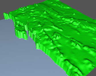 After loading the .pf file, I scaled the height and changed the color of the sea. Andy |
|
|
|
|
10th December 2003, 05:42 AM
|
#7 |
|
Junior Member
Junior member
Join Date: Jun 2003
Posts: 7
|
It works. Thank you for the support.
I think I have a lot of data that are useless, in particular in a flat country as ours. Hmm. Something to optimise it. |
|
|
|
|
11th December 2003, 05:58 AM
|
#8 |
|
Junior Member
Junior member
Join Date: Dec 2003
Posts: 2
|
Thanks for all your help
 Just 2 things: - The applet in irony.com produces a VRML v2 file that the last AC3D for Linux (yes, it's my playground  ) cannot import (only VRML v1). I need to find a way to translate it to the previous version. Is it possible? (are they compatible?) Another way would be converting VRML to another of the formats that AC3D can read. I have to do a bit of research here... (I'm rather new to this things ) cannot import (only VRML v1). I need to find a way to translate it to the previous version. Is it possible? (are they compatible?) Another way would be converting VRML to another of the formats that AC3D can read. I have to do a bit of research here... (I'm rather new to this things - Andy, could you send me the source code for the plugin? I will try to compile it for linux ^_^ Time to do a bit of work! Jose |
|
|
|
|
11th December 2003, 06:28 AM
|
#9 |
|
Administrator
Professional user
Join Date: Jun 2003
Posts: 4,565
|
Have a look at dbyrd01's great Terrain Tutorial - he explains how to get the model into AC3D.
http://ac3d.org/forum/viewtopic.php?t=290 I'll email the source for the point field plugin now... Andy |
|
|
|
|
12th December 2003, 03:26 AM
|
#10 |
|
Junior Member
Member
Join Date: Dec 2003
Location: North CA, USA
Posts: 15
|
Can I take a grayscale image and do the same thing? I'm not readily seeing how to do that within the menus is all.
Thanks. |
|
|
|
 |
|
|


 Linear Mode

